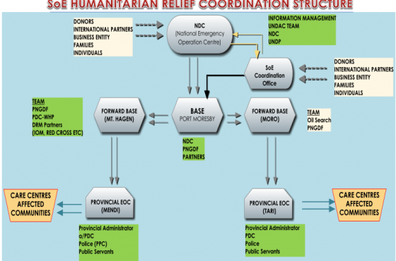
7.5 magnitude earthquake hit Highlands Region
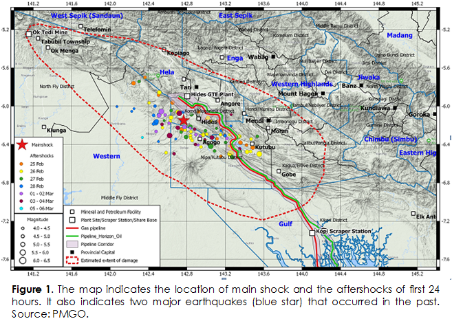
A massive 7.5 magnitude earthquake occurred on 26 February 2018 at 3:44 am caused extensive damages to buildings, public lifeline services and triggered many landslides in various location in Hela and Southern Highlands Provinces. The earthquake epicentre was at 6.2 degree south and 142.7 degree east. It is approximately 30 km south of Tari and 40 km north-west of Lake Kutubu.
The earthquake was generated as a result of movement of the Papuan Fold and Thrust Belt, which runs parallel to the axial mountain range of PNG. This fault belt runs in the SE to NW direction, from Gulf Province through Southern Highlands and Hela regions, northern sections of Western Province and into Papua Province of Indonesia. The earthquake was felt over a wide area, from Gulf and Western in the south to the Sepik Provinces in the north and to the east as far as Madang and Morobe Provinces respectively.
The fault movement in this region was typical but this one was huge and it triggered the 7.5 magnitude earthquake which was felt by many people in the highlands.
There have been occurrences of large magnitude earthquakes in this part of PNG region in the past. On 19 January 1922, a magnitude M7.5 earthquake occurred to the south of this earthquake. It occurred about 64 km southwest of Kutubu, Southern Highlands Province. On 03 March 1954, another M7 earthquake occurred to the northwest of this earthquake. It occurred about 27 km to the west of Koroba, Hela Province.